
Overview
This project demonstrates the transformation of raw LiDAR point cloud measurements into a high-resolution Digital Elevation Model (DEM) designed for reliable geospatial analysis and practical use on national level. The resulting terrain product created a precise topographic foundation that could be reused across mapping, interpretation, and broader decision-support workflows.
Project objective
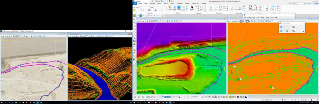
The objective of the project was to generate a high-quality digital elevation model in line with ASPRS Standard LiDAR point classes, while minimising artifacts such as random spikes and addressing typical LiDAR-related errors associated with water bodies, reflective surfaces, buildings, and vegetation.
Input data
The input data included raw LiDAR point cloud data, orthomosaics, basemaps, relevant technical literature, and client-provided technical guidance used to support quality assurance and quality control throughout the process.
Applications and value
A high-resolution digital elevation model is not only a terrain product, but a reusable geospatial asset that can support a broad range of practical applications where precision, spatial context, and defensible analysis are important. By converting raw LiDAR data into a cleaner and more reliable elevation surface, the project created a foundation that can be used across future analytical, environmental, infrastructure, and mapping workflows.
Potential applications include terrain modelling, slope and aspect analysis, contour generation, elevation profiling, landform interpretation, hydrological assessment, runoff and drainage analysis, infrastructure and corridor planning, site suitability review, landscape assessment, environmental monitoring, hazard-sensitive terrain interpretation, cartographic production, 3D terrain visualisation, and integration into wider GIS and remote sensing workflows. The model can also support baseline mapping, overlay with other spatial datasets, location-specific decision support, and future project work that depends on accurate topographic context.
The value of the output comes from both its technical quality and its operational usefulness. A reliable DEM helps reduce uncertainty, improves the quality of downstream analysis, and creates a durable product that can be reused across multiple tasks rather than rebuilt from scratch.

